
The industrial fire in Rouen: What happened?
Find information here about the fire at the Lubrizol and NL Logistique warehouses in Rouen
More information on the Post-Fire Health Program 76
Everything you need to know about the industrial fire on September 26, 2019, in Rouen and the response by Santé publique France
Where and how did the fire occur?
During the night of September 25–26, 2019, a major industrial fire broke out around 2:40 a.m. in the port area of Rouen, in Seine-Maritime (76).
Location of the industrial site and its relationship to the city of Rouen

The fire affected the storage area for finished product drums at the Lubrizol facility, which covers approximately two hectares. This facility, classified as an ICPE (Installation Classified for Environmental Protection) and a Seveso "upper-tier" site, manufactures additive products for industrial lubricants. The roof of one of the damaged buildings, made of corrugated fiber-cement sheets, collapsed around 4 a.m.
The fire also destroyed three buildings belonging to the neighboring company NL Logistique, which stored chemicals, notably from Lubrizol. NL Logistique operates four storage warehouses on its site, which is also an ICPE.
The fire was contained and brought under control that same day at 3 p.m. However, a smoldering fire, linked to damaged drums, persisted until October 7, 2019, at the NL Logistique site.
The sites and buildings of Lubrizol and NL Logistique

How many municipalities were affected by the plume of black smoke and soot deposits?
The fire generated a large plume of thick, black smoke. This plume, visible from a great distance, consisted primarily of combustion products from stored substances and other materials present at the Lubrizol and NL Logistique sites. It rose above the fire and traveled northeastward, passing over the Normandy and Hauts-de-France regions. The smoke plume rose to an altitude of 100 to 150 meters, passed over the nearest area (downtown Rouen), and then affected the northeastern part of the metropolitan area in particular.
215
municipalities affected by the plume of black smoke and soot deposits
Components of the plume fell to the ground over a vast area northeast of Rouen, and numerous soot deposits, visible to the naked eye, were observed.
The visible plume dissipated the day after the fire. In total, it is estimated that 215 municipalities were impacted by the smoke and visible soot deposits, including 112 in Seine-Maritime.
Identification of municipalities affected by smoke and soot fallout
A mathematical simulation of the atmospheric dispersion of the plume and soot deposits was conducted using the CHIMERE model shortly after the event by the National Institute for Industrial Environment and Risks (Ineris).
Map of soot (PM10) deposits simulated by INERIS (CHIMERE model)
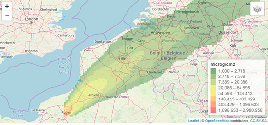
Based on visual observations conducted in the field on September 26 and 27, 2019, by the Departmental Fire and Rescue Service, the Departmental Directorate for Territories and the Sea, and the Gendarmerie, this modeling was used by the Seine-Maritime Prefecture to identify the municipalities in which to take environmental samples to characterize the pollution (see the prefectural order of October 14, 2019).
Did the fire release chemicals into the air in a way that was not visible?
A smelly but invisible plume of chemicals also spread into the air around the site of the fire. Unpleasant and persistent odors were detected on the day of the fire and, intermittently, for several months afterward: these were odors of sulfur, burning, and hydrocarbons at first, and mainly hydrocarbons thereafter. Very strong during the first few weeks, these odors were associated with health effects such as nausea, headaches, and skin and mucous membrane irritation.
The area where the odors were detected covers a large part of the Rouen metropolitan area, including municipalities that are not necessarily those where soot deposits were observed. These municipalities were identified based on reports made via the Odo app (Odor Reporting Tool), implemented by Atmo Normandie, the accredited association for air quality monitoring.
Could the fire have been the source of other health risks?
People living near the fire site may have been exposed to hazardous agents other than chemicals, including:
psychosensory in nature: auditory perception of the sounds of the fire and explosions, visual perception of flames, thick black smoke, and soot deposits;
psychological in nature: fear of the fire spreading or even a total explosion of the factory, fear of dying oneself or for loved ones, or of seeing one’s property destroyed or devalued;
fragments of fiber-cement roofing, which were propelled by explosions up to several kilometers from the fire and fell onto public and private property, and asbestos fibers that may have been dispersed in the vicinity of the site.
In the immediate vicinity of the fire
Residents living within 500 meters of the fire were advised not to leave their homes as a precautionary measure. This population, located in the town of Petit-Quevilly, was exposed even more intensely to all the hazards and, in particular, felt a threat to their physical safety and even experienced life-threatening anxiety.
Learn more about environmental monitoring of chemical pollution
Research and characterization of the chemical pollution caused by the accident in various environmental media began on September 27, 2019. This included collecting samples for laboratory analysis from surfaces and rainwater, the air, drinking water and aquatic environments, soil and vegetation, lichens, and agricultural crops and products.
Sampling and chemical analyses were conducted, depending on the environmental medium, by Atmo Normandie, the Regional Health Agency, INERIS, the Departmental Directorate for Population Protection, the French Agency for Biodiversity, the Regional Directorate for Food, Agriculture, and Forestry, the Departmental Council, the Seine-Normandy Water Agency, Air Lichen, and by laboratories commissioned by the companies Lubrizol and NL Logistique.
The results of the measurements are published on the Seine-Maritime Prefecture’s website as they become available.